1. Planning Ahead
Some of the tools I use which may help give some indication of what lies ahead for the next few days are:
Windguru

Windguru is one of the better tools for seeing a few days ahead. It can only be relied upon for about 3 days ahead. It gives average wind speed and gust speed as well as direction. The difference between gust speed and average speed will tell you roughly if the wind is going to be consistent. Doesnt always work in reality though. A better way I have found is to look at the difference between the highest speed and the lowest for the the daylight hours. If it is a low number then the wind might be more be pure and dense. e.g. on the chart above the wind on the Monday is likely to be more consistent than Sunday as it blows more or less the same strength all day, just getting stronger for the 5 o clock push.
However in Cape Town it is not accurate in terms of the higher wind speeds. Generally a rule of thumb is that you can add between 5 and 10 knots to the prediction if it is showing winds more than 20 knots. E.g. on the day shown above Winguru was showing a predicted speed of 21 knots with gusts to 25 at 11 am. The actual reading at 10 am was 25 knots gusting to 36. Further up the west coast such as Langebaan the predicted speeds are fairly accurate. This might be to do with the prediction tool not being able to calculate the effect of the topography has on wind - in Cape Town's case the mountains. I have also experienced this at Sedgefield where the neighbouring cliffs channel the wind into higher speeds than predicted.
Winguru is comprehensive tool as it shows swell height, period and direction. These are all important. Swell direction can mean the difference between good swell and tiny swell. For instance in Cape Town when the swell sometimes goes south east in summer, the waves on the north of the peninsula are reduced as the peninsula forms a type of shield that they have to go around. So waves at Kitebeach for example will become really small. Swell period can mean the difference between choppy messy swell ( short period 6 - 10 secs ) and solid well built swell ( period of 14 to 18 secs ).
Windguru also shows cloud cover and precipitation which it is mostly pretty accurate with.
Magic Seaweed
A good tool for swell prediction. Intended mainly for surfers, it rates the swell based on a number of factors one of them being wind direction and strength. Wind direction, if counter to the direction of break, can turn what should be a solid swell to mush within a short period or when off shore can make even small swells clean and very rideable.


Magic Seaweed gives the tide times which Winguru doesnt. It is also important to choose the time relative to the tides as these can produce currents which affect performance e.g. at Langebaan the channels in the lagoon flow in as the tide comes in and out when the tide goes out. When the flow is with the wind you effectively lose a bit of wind speed, however when the flow is against the wind is effectively increased and the traction is enhanced. Also, at high tide some sites break close to the shore, whereas at low tide they break further out. This is useful to know if you are learning to kite, or are learning to ride waves.
The site shows a little map of the site and the wind direction which can be useful if you are going to a new spot. It also gives sunset times which can be good if you are planning a long day out, or want to nip for a kite after work. I dont look at the wind on this site as it is in kilometres per hour and is also inaccurate. What it does do though is it shows the wind during the night which is sometimes useful to gauge when seeing if a windy spell is consistent. It also can give an indication of how the swell is going to be at the start of the day as a windstill night will allow the swell to build, whereas an onshore night will result in more choppy swells with whitewater conditions from the start of the day.
For those who are also surfers it has really nice pics and videos which are updated every day.
Windfinder
I dont use this much but I know people who do. It has basically the same information as windguru. The readings vary though sometimes, and I end up using both, especially if the wind is on the edge of being kiteable and I am looking for a spot to go to.

Wavescape
Wavescape is really a surfing site but it has access to a range of prediction tools. It is enjoyable to browse around on as well.
Here is one of the tools - an animated wind pattern forecast.

2. On the Day
Once you have an idea of what is expected, you can plan to kite on a specific day. However no prediction tool is really accurate and before you pack your car to get to the kite spot it is really advisable to check out what is really transpiring so you can assess what kites, line lengths, and boards to take or even whether the spot is working or not. Most of us have been on journeys and when we get to the spot the wind is too light or to strong to use what we have brought. These are a list of some useful tools.
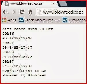
Blowfeed
For those planning to go to kitebeach or surrounds, blowfeed is useful as it gives live speeds. It is sometimes off line, especially in winter.

Milnerton Aquatics Club
If blowfeed is down or just as an extra check use the Milnerton Aquatics Club live feed. This is located on the Rietvlei lagoon, so is fairly close to Kitebeach.

Sharkwind
Sharkwind is a site with predictions at virtually every kite spot you can know of and more. It has a longer term prediction tool, but I dont generally use it, as it doesnt show gustiness or surf conditions. However it does show live speeds. It also has a map with wind direction and a graphic of kite movement relative to the wind. It even recommends a kite size. I would advise you check the speeds with another resource just to make sure, as though it is indicating a live speed that corresponds to blowfeed at the moment, it's live speed for Doodles is about 10 knots too low.


Find Out Before You Go
This is a very useful site, as you can see speed and direction as a time graph. It is 2 hours behind but you can sms a number given on the site or even subscribe and get live speeds. It is also useful because it shows gusts, lulls and the average, so you see how dense the wind is. It also has a number of sites around South Africa. I use it after I have kited as well so I can see what speeds I was kiting in and assess how the kite and equipment worked in these speeds. It's live speeds seem to be a bit lower than blowfeed by a few knots especially with the higher wind speeds.

Webcams
I use a few webcams at various times.
Muizenberg
The webcam at Muizenberg is useful if you are planning to go to the Kitebeach vicinity and the wind want to make sure the wind will arrive. If the Muizenberg site has white horses and chop whereas kitebeach is windstill, you can be sure within a couple of hours the wind will hit. The webcam can be accessed through The Corner Surf Shop website.

Kitebeach
There is a webcam on Kitebeach. It can be accessed through the Find Out Before You Go web site. It has a few other webcams at various other spots. There are two cameras and the one shows the mountain on which you can also see the cloud formation which I will explain later.

Big Bay
The webcam at Big Bay is another one I use. It can be accessed through the Atlantic Surf shop website.

The Cloud Pattern on Table Mountain.
The cloud formations on the mountain can be used to predict the actual wind conditions on the day. It is good to use a couple of websites first so you can have an idea, as the clouds can look really promising and then change if the wind was going to fade, or the clouds can appear later in the day and give signs of strong wind in a short period. There are days however when windguru is forecasting 20 knots and you look at the mountain and know that it's going to blow much harder from the outset. These are some patterns that I have observed.The more seasoned might have their own clues.
Photo below: Benign wind conditions. The flatness of the cloud underneath means that wind fairly controlled. The compactness of the cloud means solid wind. 16 - 20 knots average from south south east or south east.

Good conditions. The bulkiness of the cloud probably means 18 - 22 average knots from south south east or south east. The flatness of the line underneath means fairly controlled wind. ( Photo below )

The build up over Devil's Peak and the cloud swirling downwards and moving in waves towards the cable station means strong winds 20 - 30 knots and gusts to 35 knots. ( Photo below )

The cable station area starting to grow moving horn-like clouds. The uneveness of the bottom of the cloud, it's constant swirling, and the projection down the side of the mountain means winds strong around 25 - 30 knots with gusts to 40 knots.

A wider angle on the buffalo type beast. ( Photo below )

The mountain is virtually covered. The twelve apostles are cloaked. The wind is full tilt, blasting out 25 -35 knots. The smoothing out of the top of the cloud is a sign of the focus of the wind. ( Photo below )

The mountain is covered, but note the cloud is split at Devil's peak and the top of the lower section is smoothed of and starting to look a bit like a nuke explosion. Wind is nuclear gusting up to possibly 50 knots on occasion.
